Roadways could be slippery
Snow falling across much of New Hampshire; wintry mix, rain elsewhere to eventually switch to snow
Roadways could be slippery
Video Player is loading.
Current Time 0:00
Duration 0:00
Remaining Time 0:00
Winter storm warnings. Winter weather advisories remain in effect through late this afternoon and early this evening as we are seeing *** lot of snowfall in *** wet snow across *** lot of inland portions of the state, you should get closer to the coastline and along the coastal plain. We’ve been seeing *** mix and or rain which will ultimately lead to reduced amounts compared to what we will see inland. But even there, closer to the coast, you’ll be switching over to snow before this wraps up, we will be seeing that snow and mixed continue early this morning with some tough travel out there for the morning commute and then we end as snow later this afternoon and early this evening. Even at the coastline in between systems tomorrow, another system which initially starts the snow but likely goes to *** mix or rain later, Wednesday night and early thursday in southern New Hampshire. So some tough travel out there today as that wet snow continues to stick to area roadways, especially the side roads and the untreated surfaces. We’ve been seeing rain and *** lot of it quite heavy as we have gone closer to the coastline, but even there likely switching to snow before this wraps up later on this morning and into the afternoon. The wind expected to gust over 20 to 25 miles an hour and could lead to some scattered outages because of that there is the area of low pressure making its way through the colder side has meant all snow for central western and northern New Hampshire. While the closer you get to the coastline, it has been rainfall with *** rain snow line very definitive in and around the Manchester area. Out through the coastline through Rockingham county highs. Today will only be in the low and mid thirties and again the snow continues for *** lot of areas that have been seeing snow while that mixture line eventually fades all the way to the coastline and then moves offshore by lunchtime, everyone seeing snow away from the mountains through the afternoon before wrapping up late in the day and early this evening lows will be in the teens and twenties overnight. Tonight tomorrow partial sunshine, *** breeze out of the northwest gusting over 20 to 25 miles an hour which will ultimately take any of that snow we have on the trees and blow it away. *** couple of snow showers up north and then after some early sun, Wednesday clouds thicken, another burst of snow moving in by late in the day, Wednesday and Wednesday night, depending on the track of the system, which could be just *** little bit farther inland. That could mean that snow changes to *** mix or rain closer to the coastline before wrapping up late morning and early afternoon. On thursday, before we go back in between systems for friday ahead of *** couple of snow showers over the weekend. Greatest totals looking to be in southwestern central New Hampshire all the way up through the lakes region and the Mount Washington Valley, widespread 6 to 10 inch amounts, and, yes, there will be *** couple of spots over 10 inches of accumulation, lesser amounts farther south and east to go with the least amount of snow hours out of this system and eventual change over to snow, though is expected in southeastern areas of the state, with lesser amounts in far northern areas, *** little bit of shadowing going on with the mountains. Next system, as I mentioned, initial snow, Wednesday late afternoon and Wednesday night, switching to *** mix or rain before wrapping up thursday.
Snow falling across much of New Hampshire; wintry mix, rain elsewhere to eventually switch to snow
Roadways could be slippery
The latest storm brought more snow to New Hampshire overnight to make for a messy start to the workweek.A winter storm warning is in effect through 10 p.m. Monday for most of New Hampshire south of the White Mountains, while a winter weather advisory is in effect for the same timeframe for the immediate coastline, the mountains and the North Country. >> Weather alerts The precipitation arrived as snow for most areas, but a rain-snow line developed over southeastern New Hampshire overnight. Colder air is expected to crash back toward the coast Monday, changing any rain or wintry mix over to snow by midday.The snow will continue inland until it shuts down from northwest to southeast between mid-afternoon up north and early evening at the coast. >> Interactive Radar | Traffic trackerTemperatures will be in the 30s Monday with a northerly wind gusting 10-20+ mph.When it’s all said and done, an accumulation of 6 to 10 inches of snow looks likely from the Monadnock Region, to Concord, to the Lake Sunapee Area, to the eastern Lakes Region and into the Mount Washington Valley. Lower totals are expected farther southeast where we see more mixing. Totals will also be a bit lower north of the White Mountains where the duration and intensity of the snow will be lower.>> See the hour-by-hour timeline:The storm will continue to have a significant impact on travel conditions Monday. Snow-covered roads will make for very slippery travel. In addition, several inches of wet, pasty snow could create the risk for some isolated power outages as gustier winds pick up.ANOTHER STORM MID-WEEK?Behind this storm, skies partially clear tonight and some sun returns on Tuesday with a few late-day snow showers up north.Another messy winter storm system moves in Wednesday afternoon into Thursday. Right now, it looks like this system will bring snow and some a wintry mix to start before changing to rain for southern zones.Stay tuned to the Storm Watch 9 team for updates.Be weather aware! Download the WMUR app for Apple or Android devices and turn on push notifications. You can choose to receive weather alerts for your geolocation and/or up to three ZIP codes. In addition, you can receive word when precipitation is coming to your area.Follow the Storm Watch 9 team on social media:Mike Haddad: Facebook | TwitterKevin Skarupa: Facebook | TwitterHayley LaPoint: Facebook | TwitterJacqueline Thomas: Facebook | TwitterMatt Hoenig: Facebook | Twitter
MANCHESTER, N.H. —
The latest storm brought more snow to New Hampshire overnight to make for a messy start to the workweek.

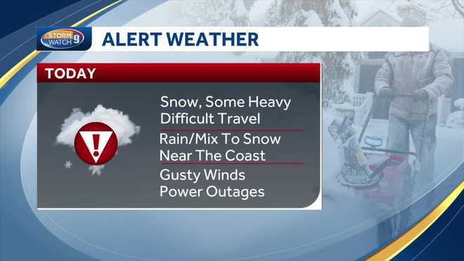
A winter storm warning is in effect through 10 p.m. Monday for most of New Hampshire south of the White Mountains, while a winter weather advisory is in effect for the same timeframe for the immediate coastline, the mountains and the North Country.
The precipitation arrived as snow for most areas, but a rain-snow line developed over southeastern New Hampshire overnight. Colder air is expected to crash back toward the coast Monday, changing any rain or wintry mix over to snow by midday.
The snow will continue inland until it shuts down from northwest to southeast between mid-afternoon up north and early evening at the coast.
>> Interactive Radar | Traffic tracker
Temperatures will be in the 30s Monday with a northerly wind gusting 10-20+ mph.
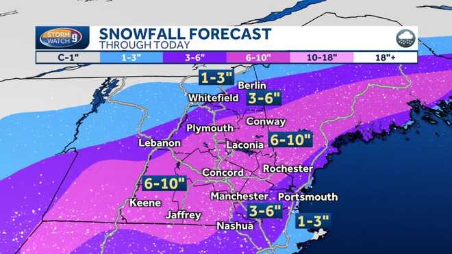
When it’s all said and done, an accumulation of 6 to 10 inches of snow looks likely from the Monadnock Region, to Concord, to the Lake Sunapee Area, to the eastern Lakes Region and into the Mount Washington Valley.

Lower totals are expected farther southeast where we see more mixing. Totals will also be a bit lower north of the White Mountains where the duration and intensity of the snow will be lower.
>> See the hour-by-hour timeline:
Video Player is loading.
Current Time 0:00
Duration 0:00
Remaining Time 0:00
The storm will continue to have a significant impact on travel conditions Monday. Snow-covered roads will make for very slippery travel.
In addition, several inches of wet, pasty snow could create the risk for some isolated power outages as gustier winds pick up.
ANOTHER STORM MID-WEEK?
Behind this storm, skies partially clear tonight and some sun returns on Tuesday with a few late-day snow showers up north.

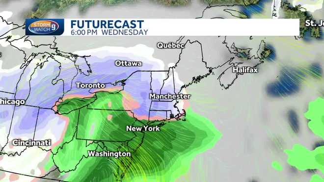
Another messy winter storm system moves in Wednesday afternoon into Thursday. Right now, it looks like this system will bring snow and some a wintry mix to start before changing to rain for southern zones.
Stay tuned to the Storm Watch 9 team for updates.
Be weather aware! Download the WMUR app for Apple or Android devices and turn on push notifications. You can choose to receive weather alerts for your geolocation and/or up to three ZIP codes. In addition, you can receive word when precipitation is coming to your area.
Follow the Storm Watch 9 team on social media:


